Macaulay Maps - Soil Maps Uncoloured 1:50 000
MacaulayMaps is a new service supplying maps and related publications that are available from The James Hutton Institute. We offer a series of soils maps and climate, forestry and agricultural suitability maps, at various scales.
Maps can be ordered online by clicking "add to cart" next to the chosen product. Maps are paid for using your credit/debit card or PayPal account.
Please note that digital version of the paper maps are not available for download or purchase, however the digital data which forms the map content (e.g. Land Capability or Soils data) is available to from the Scotland's Soils website under an Open Data licence.
General enquiries are available via e-mail
More information and ordering details are available from: David Donnelly Tel: 01224 395265.
Soil Maps Uncoloured 1:50 000
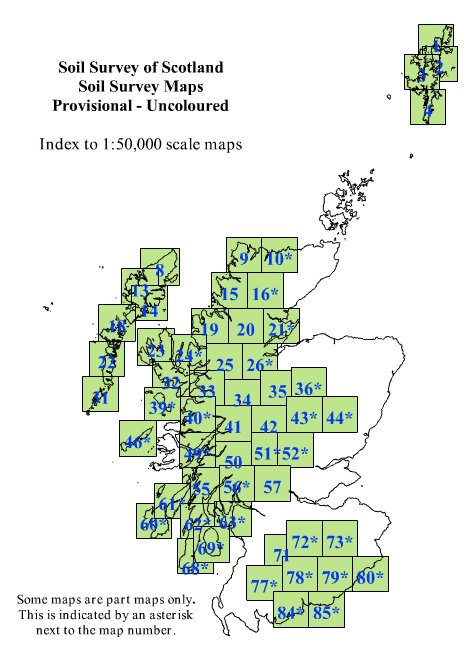
The sheet lines conform to the Ordnance Survey Landranger series. Sheets are normally supplied folded, but flat maps are available also. An index of the map areas can be found below (click to enlarge).
* Indicates part sheet.
Price (GBP): 28.80 (includes postage)
| Area | |
| 1 Shetland - Yell & Unst | |
| 2 Shetland - Whalsay | |
| 3 Shetland - North Mainland | |
| 4 Shetland - South Mainland | |
| 8 Stornoway & North Lewis | |
| 9 Cape Wrath | |
| 10* Strathnaver* | |
| 13 West Lewis & North Harris | |
| 14 Tarbet & Loch Seaforth | |
| 15 Loch Assynt | |
| 16* Lairg & Loch Shin* | |
| 18 Sound of Harris | |
| 19 Gairloch & Ullapool | |
| 20 Beinn Dearg | |
| 21* Dornoch Firth* | |
| 22 Benbecula | |
| 23 North Skye | |
| 24* Raasay & Loch Torridon* | |
| 25 Glen Carron | |
| 26* Inverness* | |
| 31 Barra | |
| 32 South Skye | |
| 33 Loch Alsh & Glen Shiel | |
| 34 Fort Augustus | |
| 35 Kingussie | |
| 36* Grantown & Cairngorm* | |
| 39* Rhum & Eigg* | |
| 40* Loch Shiel* | |
| 41 Ben Nevis | |
| 42 Loch Rannoch | |
| 43* Braemar* | |
| 44* Ballater* | |
| 46* Coll & Tiree* | |
| 49* Oban & East Mull* | |
| 50 Glen Orchy | |
| 51* Loch Tay* | |
| 52* Aberfeldy & Glen Almond* | |
| 55 Lochgilphead | |
| 56* Loch Lomond* | |
| 57 Stirling & the Trossachs | |
| 60* Islay* | |
| 61* Jura & Colonsay* | |
| 62* North Kintyre* | |
| 63* Firth of Clyde* | |
| 68* South Kintyre* | |
| 69* Island of Arran* | |
| 71 Lanark & Upper Nithsdale | |
| 72/73* Upper Clyde Valley/Galashiels & Ettrick Fores* | |
| 77/78* New Galloway, Glen Trool/Nithsdale* | |
| 79/80* Hawick & Eskdale/The Cheviot Hills* | |
| 84/85* Dumfries/Carlisle & Solway Firth* |


