Macaulay Maps - Soil Maps Coloured 1:63 360
MacaulayMaps is a new service supplying maps and related publications that are available from The James Hutton Institute. We offer a series of soils maps and climate, forestry and agricultural suitability maps, at various scales.
Maps can be ordered online by clicking "add to cart" next to the chosen product. Maps are paid for using your credit/debit card or PayPal account.
Please note that digital version of the paper maps are not available for download or purchase, however the digital data which forms the map content (e.g. Land Capability or Soils data) is available to from the Scotland's Soils website under an Open Data licence.
General enquiries are available via e-mail
More information and ordering details are available from: David Donnelly Tel: 01224 395265.
Soil Maps Coloured 1:63 360
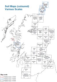
Maps are available in both flat and folded versions. An index of the map areas can be found below (click to enlarge).
Price (GBP): 28.80 (includes postage)
| Area | |
| 1-4 Stranraer, Wigtown etc. | |
| 7/8 Girvan & Carrick | |
| 14 Ayr | |
| 17 Jedburgh | |
| 18 Morebattle | |
| 22 Kilmarnock | |
| 23 Hamilton | |
| 24/32 Peebles & Edinburgh | |
| 25 Kelso | |
| 26 Berwick-on-Tweed | |
| 30 Glasgow | |
| 31 Airdrie | |
| 33/34 Haddington & Eyemouth | |
| 39 Stirling | |
| 40/41 Kinross & Elie | |
| 35/36/43/44/51/52 Island of Mull | |
| 47 Crieff | |
| 48/49 Perth & Arbroath | |
| 56 Blairgowrie | |
| 57 Forfar | |
| 66/67 Banchory & Stonehaven | |
| 75 Tomintoul | |
| 76 Inverurie | |
| 77 Aberdeen | |
| 83/84/93/94 The Black Isle | |
| 84 Nairn & Cromarty | |
| 85/95 Rothes & Elgin | |
| 86 Huntly | |
| 87/97 Peterhead & Fraserburgh | |
| 94 Cromarty & Invergordon | |
| 96 Banff | |
| 103 Golspie | |
| 109/115 Achentoul & Reay | |
| 110/116 Latheron & Wick |


